COVID-19 travel restrictions got you down? Do you want to
visit someplace where you don’t have to wear masks indoors, don’t have to be
tested or quarantined on arrival, and don’t have to produce a vaccine passport
along with your regular passport? Someplace where bars, restaurants and other
indoor gathering places are not subject to capacity limits and other
restrictions? Consider a visit to Patria! The following visitor’s guide to
Castoropolis is based on one of Patria’s old long-defunct Geocities web pages dating
from the Clinton
administration.
Patria's capital city and its largest city, Castoropolis --
known in Sanskrit as Kashipura --
contains features of other capital cities planned and built from scratch in the
modern era, such as Washington, Brasilia,
Canberra,
and New Delhi - particularly in its radial street layout in which the Capitol
is the central hub, wide boulevards and diagonal connecting streets, and
central green space or "Common". It is centered on the Island of Castoropolis,
a nearly round island in the St. Joseph River
- which has since been officially renamed Naya Ganga or New Ganges. In
the years following the Dharmic Revolution of 1989-90 many Anglo-sounding names
of places and streets in Patria have been Sanskritized. But just as in India, where English street names in New Delhi and Bombay have been
replaced by Hindi or Sanskrit names and even the name of Bombay has been changed to Mumbai, the new
names have generally failed to catch on despite the best efforts of the
government. In the text that follows, all official Sanskrit re-namings are
indicated in [square brackets].
Orientation:
Castoropolis was established as Patria's permanent capital city by act of the
First Congressus Patriaë in 1818, only a few months after Independence,
while Congress met in the temporary capital of Hammond,
Caesarea. In the 1820s the new
city was planned and built with obvious inspiration from the plan
of Washington,
DC designed by Pierre L'Enfant. The Federal District of Castoropolis,
whose boundaries are co-extensive with the city itself, is entirely surrounded
by several cities, towns, and suburban sprawl in the Precinct of
Caesarea. The original area of the Federal District of Castoropolis
consisted only of the Island
of Castoropolis. By
the turn of the 20th century the city's built-up areas had expanded beyond the
limits of the island and so in 1917 an act of the 25th Congress incorporated
into the Federal District several towns and villages in the Precinct of Caesarea
on the east side of the Naya Ganga. One town, Crozier
Heights, fought the annexation and
remains part of Caesarea. Crozier Heights
is an upper-class enclave, like Toronto's Forest Hill or Montreal's Westmount,
home to much of Patria's Jewish community.
The Capitol building, which houses the Congressus
Patriaë, is the central focus of Castoropolis. Located only a few metres east
of the geographic centre of the Island
of Castoropolis, its dome
and rotunda are very similar in appearance to the United States Capitol.
Extending west from the Capitol is Castoropolis Common [Bhavani Bagh], a large
central park. In fact, Castoropolis Common is not unlike New
York City's Central Park, offering
a large open field for concerts, numerous recreational facilities, wooded
areas, and secluded spots for doing yoga. In the 1970s and 80s the Common
served as a hangout for drug dealers, muggers, rapists, homeless bums and other
assorted sleaze, and travelers were advised to visit during daylight hours
only, but it has since been cleaned up, thanks in part to the Federal District
government that was led by the law-and-order National Union in the 1990s and
early 2000s. A gridiron pattern of residential streets is superimposed on
the radial/diagonal plan. Streets running east and west are numbered
(beginning with First Street, one block north and south of the Capitol and the
baseline streets: Crozier St. East [Shankaracharya Marg] and Justice St
[Dasharath Marg]), while streets running north and south - with the exception
of four major arteries - have Greek letters (beginning with Alpha Street one
block east and west of the Capitol and the baseline street: Schaefer St [Shakti
Marg]), continuing until Omega Street. The island is divided into four
quadrants, relative to the Capitol: North West,
North East, South West and South East, similar to Washington, DC. Thus
there may be as many as four intersections of , for example, Sixth and Gamma Streets:
NW, NE, SW, and SE.
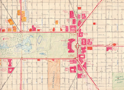
Downtown area
The map above details the central business
district at the western end of the Common. St. Joseph
[Radha-Krishna] Station handles mainly local commuter trains; most inter-city
rail traffic runs out of Union [Mahasabha] Station, a neo-Gothic rockpile (à la
Bombay's Victoria Terminus) located at
4th and Vermont
[Vaikuntha Marg] NW. Hector [Hanuman] St.
was once the capital's truly slimy side, in the last century teemng with
hookers, pimps and drug dealers. The Hector Hotel, at Hector and 4th St. SW, used to
be a notorious whore-house before it was renovated and became a guest house for
visiting swamis, swaminis, sadhus and sadhvis (Hindu holy men and women). If
you find a couple of churches but don't see any Hindu temples marked on this
map, there's a reason for it: this map dates from 1976, long before the Dharmic
Revolution.Central/midtown area
The map above details the eastern end of the
Common and the many government buildings surrounding the Capitol at the centre
of the Island of Castoropolis. Many of the
government buildings, such as the Treasury Dept., Post Office Department and
Library of Congress, are massive monuments of Art Deco kitsch, built in the
1930s as make-work projects during the Depression. Both the U.S. and
Russian Embassies are conveniently located a few blocks east of the
Capitol. The Canadian Embassy is at 200 Theta St. NW. Crozier St. East
[Poorva Shankaracharya Marg], a wide boulevard extending east from the Capitol
to the former Executive Mansion (now Shanti Mandir, a Hindu temple) on the
eastern end of the Island, is the main ceremonial parade route for Inaugural
parades, Rathyatra (the
annual Parade of Chariots) and other Hindu ceremonial processions.
Public Transit
Castoropolis Metro (Subway)
The capital's first subway line was opened in 1918 as a special project to mark
Patria's centennial year. The system has grown over the past 100-plus years to
four lines and over 150 stations.Castoropolis and Caesarea Railways
Castoropolis and Caesarea Railways (CCR) provide suburban commuter rail service
throughout the greater Castoropolis region, between downtown Castoropolis and
Hammond (the capital of Caesarea) and even into the neighboring Precinct of
Antioch, using EMU and DMU trainsets, as well as bi-level electric
locomotive-hauled trains.
Castoropolis Transit (CT) buses serve all
areas of the Federal District and the surrounding cities in Caesarea.
Most CT bus routes provide direct connections with the subway. Above, a Canadian-built
General Motors "New Look" bus, #5708, lays over at the end of Route
1, Adelphi-Philidor in 2002. The New Looks (also known as "Fishbowls") have since been retired.
Local print and
broadcast media (Don’t forget to bring your radio!)
AM Radio stations: On Nov. 23, 1978 AM radio stations in Patria, as in many other countries of the
world (except in the Americas)
shifted from 10 kHz to 9 kHz spacing. The old 10 kHz frequency is indicated in
square brackets.
PCRC, 531 kHz (ethnic, variety) [530]
PCGE, 595 kHz (Hindu) [590]
POKX, 648 kHz (right-wing talk) [650] (formerly Patria's major top
40 rocker)
PHTN, 792 kHz (Ramrajyavani-II) [790]
PMC, 846 kHz (news, talk, information) [850]
PRCC, 918 kHz (Ramrajyavani-I) [920]
PTE, 1017 kHz (Hindu) [1020]
PTCN, 1071 kHz (Ramrajyavani-III) [1070]
PMBC, 1152 kHz (all sports) [1150]
PHN, 1251 kHz (liberal-left talk) [1250]
PVOG, 1350 kHz (Christian, brokered ethnic) [1350]
PKBY, 1404 kHz (Nostalgia/MoYL) [1400]
PECR, 1512 kHz (business news) [1520]
PGBS, 1557 kHz (ethnic) [1560]
FM Radio stations:
PHUP, 88.1 MHz (educational/public, Hindu University of Patria)
PNIT, 88.9 MHz (educational/public, Patrienish National Institute
of Technology)
PUC, 89.7 MHz (educational/public, University of Castoropolis)
PCCC, 90.5 MHz (educational/public, City College of Castoropolis)
PGBS-FM, 91.3 MHz (adult contemporary)
PMC-FM, 92.5 MHz (classical, jazz)
PREM, 94.9 MHz (new age)
POKQ, 96.1 MHz (hot hits)
PRCC-FM, 99.1 MHz (Ramrajyavani-IV)
PPIX, 103.7 MHz (rap, dance, hip hop)
PMBC-FM, 104.9 MHz (C&W)
PCGE-FM, 106.7 MHz (classic rock)
PRKO, 107.9 MHz (oldies)
Ramrajyavani-I : popular music, news, information, documentaries, English/Patrienish; Ramrajyavani-II:
Hindu devotional music, Sanskrit; Ramrajyavani-III:
all-news; Ramrajyavani-IV: classical music, drama, poetry, arts.
Television stations (analog, over-the-air):
PRCT, channel 2 (Doordarshan-I); PMC-TV, channel 5;
PGBS-TV, channel 12; PLIS, channel 15; PCET, channel 46 (public broadacsting);
PQAL, channel 57 (Doordarshan-II).
Doordarshan I: news, sports, entertainment. Doordarshan-II: Hindu
devotional channel. U.S.
cable channels such as CNN and MTV are widely available in Patria.
Daily newspapers: The Akashic Record, (pro-Hindu), Castoropolis
Chronicles (left-wing paper of record, cf. New York Times or Washington
Post), The Spectrum (right-wing
tabloid, cf. Toronto Sun or New York Post), Ramrajya Dharmika Patrika (Sanskrit), Novítæ Dínaë (Patrienish).


No comments:
Post a Comment